

Land Use
Sector Results by 2050
149.6 gigatons
reduced CO2$131.1 Billion
net implementation cost$1.20 Trillion
net operational savings
- Introduction
- Solutions
- Methodology and Integration
- Results
- Sector-Level Benchmarks
- Conclusions and Limitations
- Frequently Asked Questions
- Coming Attractions
- Additional Information
Other Sectors:
Introduction
The Land Use Sector includes the protection and restoration of high-carbon ecosystems such as forests and wetlands, as well as the production of perennial timber and biomass crops. Deforestation and degradation of forest ecosystems are responsible for about 1/8 of anthropogenic greenhouse gas emissions today (IPCC, 2014). Land use solutions reduce emissions from deforestation and degradation of ecosystems. Some protected ecosystems (e.g. coastal wetlands) continue to sequester carbon, while forest restoration and timber and biomass crops sequester significant amounts of carbon. Forests, peatlands, and coastal wetlands provide critical ecosystem services as well, while timber and biomass crops produce important feedstocks for construction, paper, energy, and other uses.
Solutions
Ecosystem protection solutions:
Coastal wetlands – the legal protection of carbon-rich mangroves, seagrasses, and saltmarshes, leading to reduced degradation rates and the safeguarding of carbon sinks.
Forest protection – the legal protection of forest land, leading to reduced deforestation rates and the safeguarding of carbon sinks.
Indigenous people’s land management – the legal recognition of forest tenure to indigenous peoples’ communities with claims to the land, leading to reduced degradation rates and the safeguarding of carbon sinks.
Peatlands – the protection of carbon-rich peatlands, leading to reduced degradation rates and the safeguarding of carbon sinks.
Ecosystem restoration solutions:
Temperate forests – the restoration and protection of temperate-climate forests, resulting in ongoing biosequestration.
Tropical forests – the restoration and protection of tropical-climate forests, resulting in ongoing biosequestration.
Timber and biomass crop solutions:
Afforestation – the planting of trees for timber or other biomass uses on degraded land, with biosequestration impacts in soil and biomass, and long-lived products across periods of cultivation.
Bamboo – the planting of bamboo for timber and other biomass uses on degraded land, with biosequestration impacts in soil, biomass, and long-lived products across periods of cultivation.
Perennial biomass – the production of perennial grasses and coppiced woody plants for bioenergy feedstock, resulting in net carbon in soils through biosequestration.
Methodology and Integration
General Model Framework
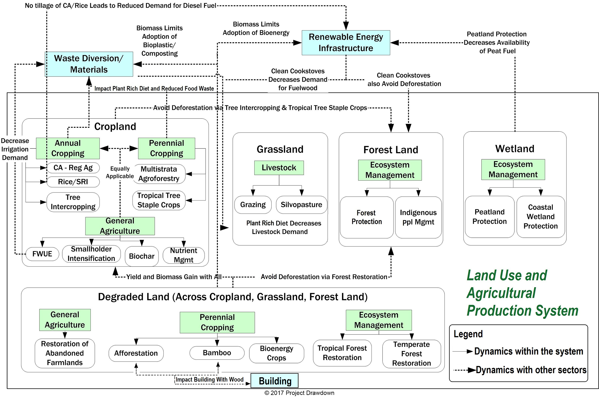
Each solution in the Land Use Sector was modeled individually, and then integration was performed to ensure consistency across the sector and with the other sectors.Information gathered and data collected are used to develop solution-specific models that evaluate the potential financial and emission-reduction impacts of each solution when adopted globally from 2020-2050. Models compare a Reference Scenario, that assumes current adoption remains at a constant percent of the current total land area, with high adoption scenarios assuming a reasonably vigorous global adoption path. In doing so, the results reflect the full impact of the solution, i.e. the total 30-year impact of adoption when scaled beyond the solution’s current status.
Figure 1: Project Drawdown Land Use Sector Framework
Total Land Area
Land Use and supply-side Food Sector models define the Total Land Area as the area of land (in hectares) suitable for adoption by solutions. Data on global land is acquired from Global Agro-Ecological Zones database, developed by the Food and Agriculture Organization of the United Nations (FAO) and the International Institute for Applied Systems Analysis (IIASA). The Drawdown Land Use Model categorizes and allocates land according to agro-ecological zones based on the following factors: thermal climate, moisture regimes, soil quality, slope, cover type, and degradation status. These characteristics influence the suitability of different practices, and solution adoption scenarios are restricted by one or more of these factors.
- Thermal climate – includes tropical, temperate, and boreal (high latitude or high elevation). Several of the agricultural solutions with the most powerful mitigation impact, like tropical staple trees and multistrata agroforestry, are limited to tropical or even tropical humid climates. Temperate forest and tropical forest are likewise limited by climate.
- Moisture regime – includes humid (1000 millimeters of rainfall or more per year), semi-arid (250-1000 millimeters per year), and arid (0-250 millimeters of rainfall per year). Several solutions are constrained by rainfall; for example, bamboo is only suited to humid climates, whether tropical or temperate.
- Soils quality – includes prime, good, and marginal. While no solutions are limited to soils of a given quality, yields decrease in good and marginal soils.
- Slope types – include minimal, moderate, and steep. Moderate and steep slopes are more vulnerable to erosion due to tillage, and are also difficult to work with mechanized equipment due to risk of rollovers. Thus, fully perennial solutions, while applicable on all slopes, are particularly advisable for steeper slopes.
- Current cover – includes forest, grassland, rainfed cropland, and irrigated cropland. Certain practices like farmland irrigation are only suited to irrigated cropland. Forest protection is only suited to currently forested areas.
- Degradation status – each agro-ecological zone is designated degraded or non-degraded. Degraded zones are suitable for restoration and show lower yields. For example, non-degraded grassland is ideal for managed grazing and silvopasture, while degraded grassland may be restored via afforestation or perennial biomass production. Degraded forest is suited to restoration via temperate forests or tropical forests.
Adoption Scenarios
Three general Project Drawdown scenario were developed for the Land Use Sector:
- Plausible Scenario: this scenario represents incremental growth of land use solutions using a high adoption trajectory to 2050.
- Drawdown Scenario: this scenario is optimized to reach drawdown by 2050 using more ambitious projections.
- Optimum Scenario: this scenario represents the most optimistic case, in which land use solutions capture 100 percent of allocated land. The scenario assumes an accelerated early adoption of protection and ecosystem restoration solutions.
Each solution model uses unique adoption trajectories evaluated based on meta-analyses of existing prognostications of solutions, extrapolations from historical data, or scenario analyses depending on the availability of global and regional data.
Integration
Drawdown’s approach seeks to model integration between and within sectors, and avoid double counting. Several tools were developed to assist in this effort. The Agro-Ecological Zone (AEZ) model categorizes the world’s land by: current cover (e.g. forest, grassland, cropland), thermal climate, moisture regime, soil quality, slope, and state of degradation. Both Food (supply-side) and Land Use solutions were assigned to AEZs based on suitability. Once current solution adoption was allocated for each zone (e.g. semi-arid cropland of minimal slopes), zone priorities were generated and available land was allocated for new adoption. Priorities were determined based on an evaluation of suitability, consideration of social and ecological co-benefits, mitigation impact, yield impact, etc. For example, Indigenous Peoples’ land management is given a higher priority than forest protection for AEZs with forest cover, in recognition of indigenous peoples’ rights and livelihoods. Multistrata agroforestry is highly prioritized in tropical humid climates due to its high sequestration rate, food production, and highly limited climate constraints.
Each unit of land was allocated to a separate solution to avoid overlap between practices. The exception to this are farmland irrigation, nutrient management, and women smallholders, which can be implemented in addition to other practices. The constraint of limited available land meant that many solutions could not reach their technical adoption potential. The AEZ model thus prevents double-counting for adoption of agricultural and land use solutions.
Modeling Saturation
Biosequestration does not have limitless potential. In most cases, there is a maximum amount of carbon that can be stored in soils and aboveground perennial biomass before they become saturated. Biosequestration continues after saturation but is offset by more or less equal emissions. In most cases, soils and biomass can return to their approximate pre-agricultural or pre-degradation levels of carbon. This takes anywhere between 10-50 years in agricultural cases, and sometimes longer in the case of ecosystems like forests. Data about saturation time is very limited.
The Drawdown land model takes the conservative approach that all land units currently adopted for land use like forest protection or afforestation have already achieved saturation, and will not be contributing additional sequestration. New adopted land is assumed to sequester for at least 30 years before achieving saturation.
Note that there are some important exceptions to saturation. Certain ecosystems continue to sequester soil carbon for centuries, notably peatlands and coastal wetlands. Some scientists argue that tropical forests can continue to sequester carbon at a slower rate after saturation. The addition of biochar to saturated soils may be able to overcome this constraint, as does the use of biomass from bamboo or afforestation in long-term products like buildings.
Results
Mitigation Impact
In Drawdown’s Plausible Scenario, Land Use Sector solutions are responsible for 14.2 percent of total emissions mitigation impact. In the Drawdown and Optimum Scenarios, they contribute 16.4 percent and 17.5 percent, respectively.
Figure 2: Mitigation Impact by Sector, 2020-2050 (in Gigatons of Carbon Dioxide-Equivalent)
Total Atmospheric CO2-eq avoided (Gt)Plausible ScenarioDrawdown ScenarioOptimum ScenarioBuildings and CitiesElectricity GenerationFoodLand UseMaterialsTransportWomen and Girls0100200300400500600
© 2017 Project Drawdown
Figure 3: Land Use Sector Plausible Scenario Emissions and Adoption Results, 2020-2050
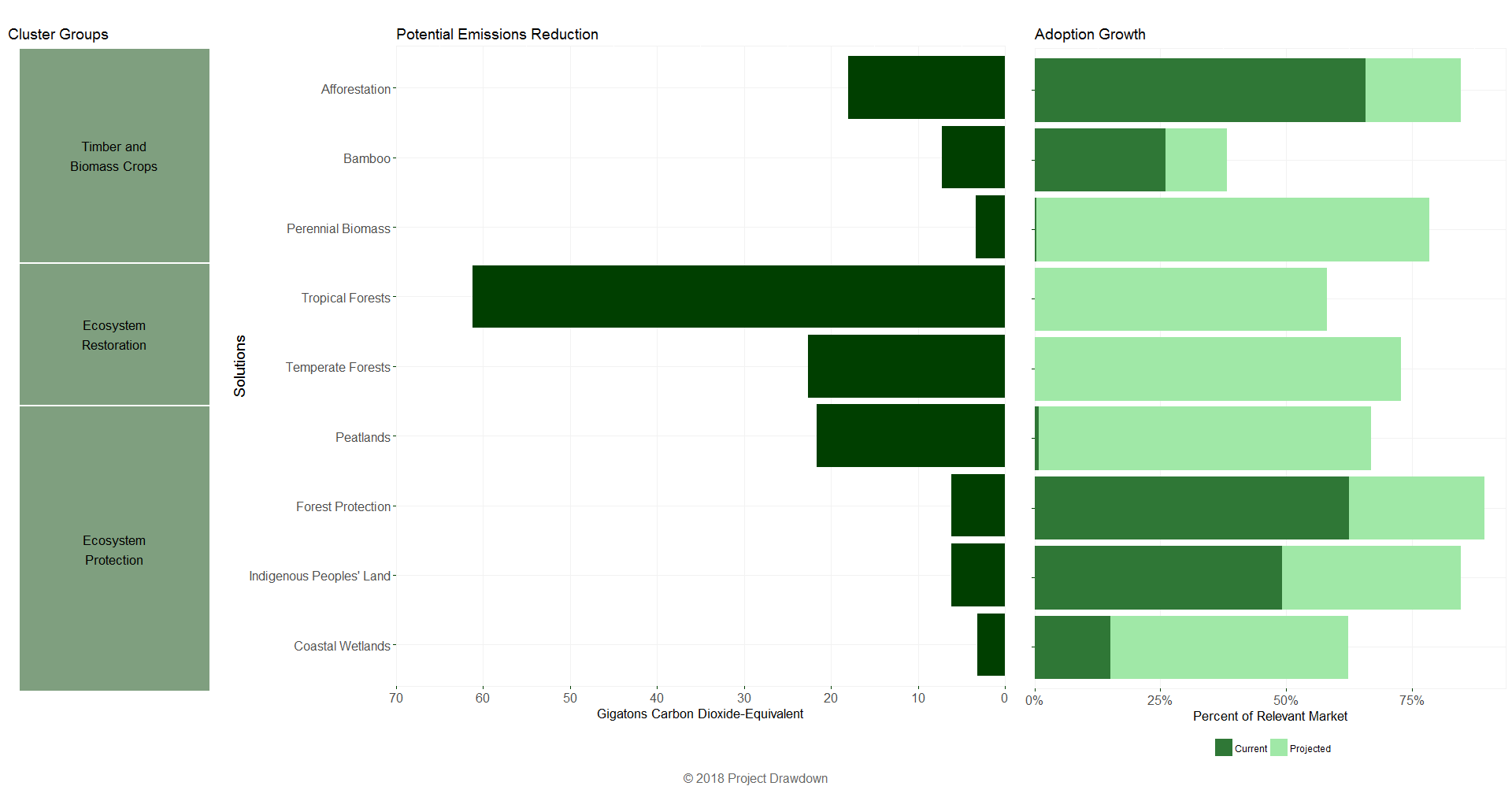
Solutions in this sector include ecosystem protection, ecosystem restoration, and timber and biomass crops. Within this sector, ecosystem restoration solutions have the greatest mitigation impact, accounting for 55.9 percent, 54.2 percent, and 52.4 percent in the Plausible, Drawdown, and Optimum Scenarios, respectively. Ecosystem protection solutions account for 25.0 percent, 23.8 percent, and 21.0 percent, respectively (though the total stock protected is much higher, see Table 7). Timber and biomass crop solutions account for 19.1 percent, 21.8 percent, and 26.5 percent of mitigation impact, respectively.
Figure 4: Mitigation Impacts by Solution—Plausible Scenario, 2020-2050 (in Gigatons of Carbon Dioxide-Equivalent)
hover for details
© 2017 Project Drawdown
Table 1: Mitigation Impact of Land Use Sector Solutions Under the Three Studied Scenarios
| Total Atmospheric Greenhouse Gas Reduction (in Gigatons) | |||
| Plausible Scenario | Drawdown Scenario | Optimum Scenario | |
| Afforestation | 18.06 | 33.51 | 36.60 |
| Bamboo | 7.22 | 13.88 | 28.90 |
| Coastal wetlands | 3.19 | 3.99 | 4.48 |
| Forest protection | 6.20 | 8.66 | 9.69 |
| Indigenous peoples’ land management | 6.19 | 8.16 | 5.19 |
| Peatlands | 21.60 | 35.11 | 42.55 |
| Perennial biomass | 3.33 | 4.20 | 4.99 |
| Temperate forests | 22.61 | 42.55 | 43.22 |
| Tropical forests | 61.23 | 89.00 | 107.06 |
| TOTAL | 149.63 | 239.06 | 282.68 |
© 2017 Project Drawdown
Per-hectare impacts were calculated using meta-analysis. Tables 2 and 3 show the ranges, which were determined based on one standard deviation above and below the mean of all data collected. Sequestration types include soil organic carbon (SOC), aboveground biomass (AGB), or both. Emissions reduction includes carbon dioxide (CO2), methane (CH4), and nitrous oxide (N2O).
Table 2: Sequestration Rates (in Metric Tons of Carbon per Hectare per Year)
| Land Use Sector Solution | Data Range | Model Input | Sequestration Type | |
|---|---|---|---|---|
| Low | High | SOC or AGB | ||
| Afforestation | -1.05 | 10.46 | 4.71 | both |
| Bamboo | 7.17 | 23.58 | 15.38 | AGB |
| Forest protection | N/A | N/A | 0.60 | both |
| Coastal wetlands – mangroves | 1.13 | 2.29 | 1.71 | both |
| Coastal wetlands – saltmarshes | 0.86 | 2.75 | 1.81 | both |
| Coastal wetlands – seagrasses | 0.49 | 1.71 | 1.10 | both |
| Indigenous People’s land management | N/A | N/A | 0.60 | both |
| Peatland | -0.13 | 2.95 | 1.41 | both |
| Perennial biomass | 0.14 | 2.23 | 1.18 | SOC |
| Temperate forests (restoration) | 1.29 | 4.64 | 2.96 | both |
| Tropical forests (restoration) | 2.15 | 4.61 | 3.38 | AGB plus roots |
© 2017 Project Drawdown
Note: Bamboo sequestration rates include carbon stored in long-lived bamboo products.
Table 3: Emissions Reduction Rates (in Metric Tons of Carbon Dioxide Equivalent per Hectare per Year)
| Land Use Sector Solution | Data Range | Model Input | Greenhouse Gas Type | |
|---|---|---|---|---|
| Low | High | CO2, CH4, or N2O | ||
| Coastal wetlands – mangroves | -5.69 | 68.33 | 31.32 | CO2 |
| Coastal wetlands – saltmarshes | 2.14 | 9.66 | 5.90 | CO2 |
| Coastal wetlands – seagrasses | 7.71 | 12.00 | 9.85 | CO2 |
| Forest protection (one time) | 173.07 | 454.51 | 313.79 | all |
| Indigenous People’s land management | 173.07 | 454.51 | 313.79 | all |
| Peatland | 9.57 | 57.38 | 33.48 | All |
| Perennial biomass | -0.16 | 0.82 | 0.33 | All |
© 2017 Project Drawdown
Ecosystem protection solution models are based on the reduction of historic degradation rates. Table 4 shows a range of degradation rates of unprotected ecosystems, determined based on one standard deviation above and below the mean of all data collected, along with the input selected for the model.
Table 4: Ecosystem Degradation Rates (in Percent per Year)
| Land Use Sector Solution | Data Range | Model Input | |
|---|---|---|---|
| Low | High | ||
| Coastal wetlands – mangroves | 0.46 | 2.03 | 1.24 |
| Coastal wetlands – saltmarshes | 1.00 | 2.00 | 1.50 |
| Coastal wetlands – seagrasses | 0.91 | 5.91 | 3.41 |
| Forest protection (one time) | 0.07 | 0.31[i] | 0.31 |
| Indigenous People’s land management | 0.02 | 0.04 | 0.03 |
| Peatlands | N/A | N/A | 0.52[ii] |
© 2017 Project Drawdown
Ecosystem protection solutions also serve as carbon stocks. Preserving these large carbon reserves is of critical importance to climate mitigation. Table 5 shows the total protected carbon stocks under the Plausible, Drawdown, and Optimal Scenarios.
Table 5: Carbon Stocks Preserved Under Protection Solutions (in Gigatons of Carbon)
| Plausible | Drawdown | Optimal | |
|---|---|---|---|
| Coastal wetlands (combined) | 14.6 | 15.9 | 16.8 |
| Forest protection | 244.6 | 257.2 | 254.8 |
| Indigenous People’s land management | 231.8 | 265.6 | 274.0 |
| Peatlands | 335.8 | 465.9 | 469.4 |
© 2017 Project Drawdown
Financial Impact
Financial impacts are not modeled for ecosystem restoration and protection solutions, as costs are highly variable and not necessarily borne by the land holder. Timber and biomass crop solutions offer substantial financial savings.
Table 6: Net Cost and Net Savings by Solution (in US2014$ Billion) – Plausible Scenario Only
| Net Cost | Net Savings | |
|---|---|---|
| Afforestation | $29.40 | $392.30 |
| Bamboo | $23.80 | $264.80 |
| Coastal wetlands | $0 | $0 |
| Forest protection | $0 | $0 |
| Indigenous Peoples’ land management | $0 | $0 |
| Peatlands | $0 | $0 |
| Perennial biomass | $77.90 | $541.90 |
| Temperate forest | $0 | $0 |
| Tropical forest | $0 | $0 |
| TOTAL | $131.10 | $1,199.00 |
© 2017 Project Drawdown
[i] The weighted average degradation rate was calculated using the country level data on total forest area and rate of deforestation available for 1990-2015 (FAO, 2015).
[ii] The annual rate of peatland degradation is estimated based on the difference in the peatland area reported for the year 1990 and 2008 by the Wetland International.
Sector-Level Benchmarks
The Intergovernmental Panel on Climate Change (IPCC) estimates that the potential for greenhouse gas emissions from global forestry of all types is 0.0-1.4, 0.1-9.5, and 0.2-13.8 gigatons. This estimate is based on prices of $20, $50, and $100 per ton of carbon dioxide emitted in 2030. Drawdown’s Plausible, Drawdown, and Optimum Scenarios for ecological protection and restoration solutions (representing comparably similar levels of adoption) achieve 5.9, 8.3, and 8.7 gigatons of reductions per year by 2050, respectively. This is well within the IPCC benchmark.
As for the timber and biomass crop solutions, the IPCC provides a benchmark of 4.0 gigatons of emissions per year in 2030 from afforestation, given a price of $100 per ton of emitted carbon dioxide per year (Climate Change 2007: Mitigation of Climate Change, Table 9.3). Drawdown’s three comparable solutions (afforestation, bamboo, and perennial biomass) achieve a combined impact of 0.5, 0.9, and 1.5 gigatons of emissions per year in 2030 in the three scenarios, respectively. Drawdown’s prioritization of food production and ecosystem restoration over afforestation is a possible reason for results lower than IPCC’s benchmark.
Conclusions and Limitations
Conclusion
Improvements to land use are critical for climate change mitigation. Ecosystem protection solutions prevent loss of carbon currently held in forests and wetlands. Ecosystem restoration solutions and perennial timber and biomass have impressive biosequestration potential. Ecosystem protection and restoration offer essential co-benefits of ecosystem services, while perennial timber and biomass produce important products. Solutions in the Land Use Sector offer biosequestration as well as emissions reduction – and a livable climate cannot be attained without removal of excess atmospheric carbon.
Limitations
Disturbance rates show the expected loss of protected and replanted forests and other ecosystems due to disturbances like fire. The model is built to include disturbance rates, but sufficient data was unavailable. This may be added to the model in the future as it becomes available. Restoration of peatlands and coastal wetlands was not modeled due to lack of data, though this is clearly desirable alongside protection. Albedo impacts are not modeled but would be useful to include in future upgrades.